

Redistricting map proposals have been released for Washington’s 49 legislative districts, and analysts and party representatives on both sides of the aisle are calling foul.
Each of the four Redistricting Commission commissioners released their own proposed map on Tuesday. Now they have until Nov. 15 to hash out their differences and approve a final proposal. During a normal redistricting session, commissioners hash out maps and then present them to the public.

The Morning Wire: Keeping you informed on politics, policies, and personalities of Washington State.
But this year the data from the federal Census Bureau was delayed, meaning there’s less than two months for Washingtonians to weigh in on the proposed maps. If the commissioners can’t decide on a final map, then the state Supreme Court will. A high-quality version of the current LD map can be viewed here.
Already, representatives from both the state Democrat and Republican parties are unhappy with the maps from the other side’s commissioners, and the term gerrymandering is surfacing.
Both Republican commissioners, Paul Graves and Joe Fain, emphasized creating more competitive or swing districts across the state. Graves states his map will nearly double the amount of competitive or swing districts from six to 11, while Fain says his maps will create 15 such districts. Fain also stated he focused his maps along school district boundaries.
Washington State Republicans Chair Caleb Heimlich praised those proposed increases.
“Our hope at the end of the day is that we have more competitive districts, not less, that we empower the voters,” Heimlich said.
Neither of the Democratic commissioners, Brady Piñero Walkinshaw or April Sims, discussed competitive districts in their map statements. But Alex Bond, spokesperson for the Washington Democrats, said the focus on competitiveness between parties is misplaced. He pointed to the highly-competitive 2020 election in the 5th LD, which pitted incumbent Democratic Sen. Mark Mullet against a progressive challenger, Ingrid Anderson.
Bond views the Republican commissioners’ maps as essentially partisan, and drafted through a political lens to boost their party’s performance.
“Democrats believe that the focus should come first and foremost on communities and districts that make sense on the ground to real people, and not political operatives,” Bond said.
Heimlich said much the same of the Democratic maps, saying the proposed maps were not made in good faith.
“Both of these Democrat proposed maps are gerrymandered to the extreme to give Democrats the maximum electoral advantage,” Heimlich said.
The Wire has requested partisan advantage change data from each of the commissioners’ staff, and will update this story when it is provided. Each district is required by state law to be as close to the population target of 157,251 as possible.
Democrat concerns
Several proposals within Republican drafts concern Democrats, specifically changes to the 38th, 13th, and 24th LDs.
By state law, districts are supposed to be connected geographically and represent communities of interest. Fain’s proposal for the 24th LD would marry the peninsula formed by the Hood Canal with the Olympic Peninsula, apparently by way of a strip of land just wide enough to fit State route 106, Bond said.
A series of two screenshots below shows the tip of the Hood Canal peninsula. The yellow shading is the 24th LD under Fain’s plan. The second screenshot is a magnified version of the same photo:
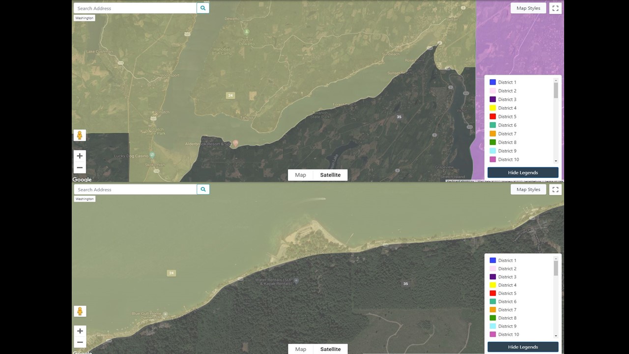
“What we saw is them pushing the boundaries of what’s legal, and perhaps crossing them in an attempt to draw lines that would benefit Republican candidates politically,” Bond said.
Another proposal from Graves would extend the 13th LD from the outskirts of Issaquah to the west, to nearly Spokane in the east. Its western border currently runs along the Cascades, and borders the now-blue 5th LD in the Snoqualmie Valley. Graves’ proposal would shrink the 5th LD to incorporate Sammamish, Issaquah, and portions of Newcastle, while incorporating the cities of North Bend, Snoqualmie, and Carnation into the 13th.
Graves’ proposed 13th LD can be seen below in magenta, stretching from near Spokane to Puget Sound:
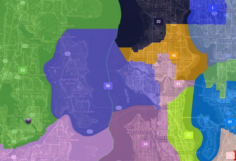
There’s also a proposal from Fain to merge Seattle’s Magnolia, Queen Anne, and parts of the Ballard neighborhoods with Bainbridge Island in the 36th LD which confused Andrew Villeneuve of the Northwest Progressive Institute. The proposed district would cross county lines, unlike Vashon Island which while it’s in the 34th LD along with West Seattle, is also a part of King County.
That proposal can be seen below:
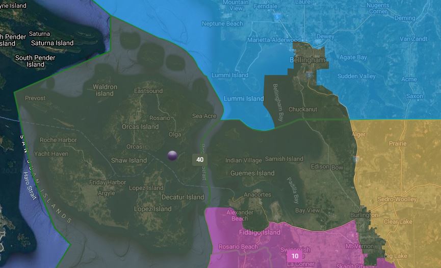
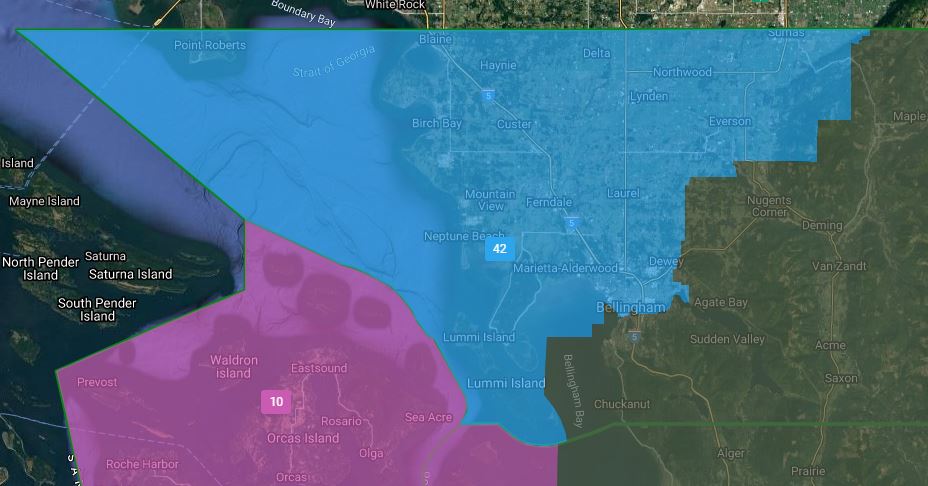
Both Republican plans also carve out liberal Bellingham, largely removing it from the more Republican-safe 42nd LD and moving it firmly into the 40th LD along with Anacortes and the San Juan Islands.
Fain’s Bellingham:
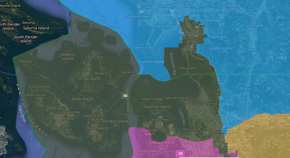
Graves’ Bellingham:
Republican concerns
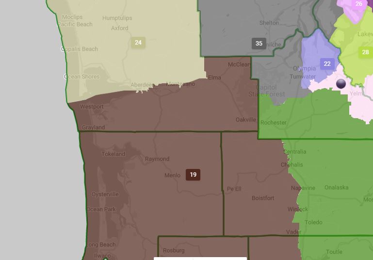
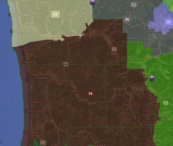
On the other side, Republicans are worried that the Democratic maps will unseat incumbents. Alex Hays, a GOP political consultant, pointed to the proposals from Sims and Walkinshaw that both remove Aberdeen from the 19th LD, which could effectively unseat Republican Rep. Jim Walsh.
Sims’ Aberdeen:
Wakinshaw’s Aberdeen:
Both Hays and Heimlich had concerns about Democrat proposals for northwest Washington in the Bellingham area. Both Democratic proposals would put Bellingham and Lynden — currently represented by Republican Rep. Doug Erickson — in the 42nd District, and incorporate the San Juan islands into the 10th, while moving the 40th LD to incorporate eastern portions of Whatcom and Skagit counties.
Both Sims’ and Wakinshaw’s drafts are similar, with Wakinshaw’s extending further east and incorporating Everson. Wakinshaw’s is pictured here:
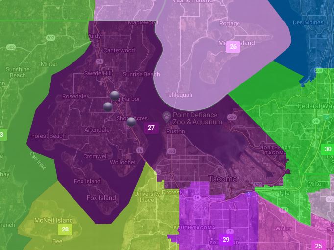
On top of the 10th and 42nd LDs, Heimlich also pointed to Wakinshaw’s proposal to stretch the 27th LD across the Narrows Bridge, and incorporate north Tacoma and Gig Harbor.
“That’s the definition of gerrymandering, if you’re ignoring a very specific contiguous geographic boundary,” Heimlich said.
That 27th LD proposal can be seen below:
Heimlich said he views the Democratic maps as trying to create 16 safe Republican districts, while ensuring there are more than 30 safe Democrat districts. He called it a power grab to secure legislative majorities.
Washington’s power balance
As has been pointed out by the Wire’s DJ Wilson, Washington State law essentially guarantees that there will be a 50-50 split on a map. The statute and state constitution lays out that district boundaries can’t favor or discriminate against one party, and because three of the four redistricting commission members have to agree on the map, it lends itself to giving roughly equal weight to both parties.
What that means in a state like Washington, where in a “wave” election like 2018 which saw 58% of voters statewide cast for Gov. Jay Inslee, compared to 42% for the Republican, only 53% of Senate seats went to Democrats, and only 51% of the House turned blue. While there’s likely other factors playing in here, it’s hard to argue that the way Washington draws its district maps gives a significant boost to Republicans.
Villeneuve said he would like to see districts drawn to more accurately represent Washington’s left-leaning disposition with Democratic majorities in the Legislature. At the same time, Republicans represent a significant minority party.
“The Republicans need to be fairly represented because there are Republican voters in the state, but they shouldn’t be overly represented,” Villeneuve said.
On the other side, Hays said he doesn’t expect the Democratic maps, if approved, to sustain challenges in court, and that the maps proposed by Graves expressed the most deference to voters.
It’s also worth noting that this Redistricting Commission was the first to have a Tribal consultation policy. Five Tribes provided feedback to the Commission, and all four commissioners said they honored those requests. Four of the requests were to maintain the status quo, but the fifth was from the Yakama Nation, asking to have their reservation and Tribal lands consolidated into a single district.
Congressional District maps are due out on Sept. 28, after which there are only two public hearings scheduled for Washingtonians to weigh in on the maps. The first on the LD maps is scheduled for Oct. 5 at 7 p.m., and the second on CD maps is set for Oct. 9 at 10 a.m.
Your support matters.
Public service journalism is important today as ever. If you get something from our coverage, please consider making a donation to support our work. Thanks for reading our stuff.